Showing posts with label Cloud Computing. Show all posts

Wednesday, July 21, 2010

GIS Applications Take to the Clouds


For ikke så længe siden forudsagde jeg at GIS var som skabt til skyen, men at det ville tage tid inden den nåede derop ... Heldigvis tog jeg fejl ;-)
/Sik 


A while back I predicted that GIS would be great news in the cloud but did not see it coming for a while ... Fortunately I was wrong ;-)
/Sik


Quote

Geographic Information Systems (GIS) applications have been moving into the cloud with increased momentum but like other fields where software drives the business model, the move from complex software to the software as a service cloud model was slow to catch on due to the business of delivering software—not the technological constraints of doing so. This presents a new market for those previously locked out of GIS due to high startup costs and a potential paradigm shift for how this niche segment of the software industry does business from now on. The GIS example is representative not only of how large-scale application areas are tentatively approaching the cloud from a technological and business model standpoint, but how such shifts can begin to have an instant impact on the new user groups enabled by the delivery model.


The diverse field of Geographic Information Systems (GIS) has seen greater demand for its wide array of geospatial technologies, not only because the mainstream internet has allowed for a much richer, more inclusive way to map just about anything that is a noun via a sort of unconscious crowd-sourcing of metadata and geotagging, but because the applications for such data are growing. GIS technologies have traditionally been used in predictable ways in the foresntry, civil engineering and development areas, as well as in natural resource exploration and the culling of general population data for use by agencies and organizations of all sizes and purposes. As mapping has become more detailed and the underlying technology behind it more powerful, GIS has been increasingly used in marketing and consumer trend identification—and you can let your imagination take you from there. [...]

Read more: http://www.hpcinthecloud.com/features/GIS-Applications-Take-to-the-Clouds-98889954.html

Monday, July 12, 2010

Find & Report Civic Issues Around You


Vi er alle potentielle informanter ...
/Sik


We're all potential informers ...
/Sik

Quote


Read more: http://www.citysourced.com/

Amtsdata i skyen


Lokal sky? Global sky? Inklusive Cloud Services adgang med lettere integration af data? Spændende, men hvad er ambitionsniveauet på sigt?
/Sik 


Only Danish ...
/Sik

Quote


Alle de gamle amtsdata, der ligger på Sikringsserveren, vil i løbet af sommeren blive flyttet i skyen. Og nej - det er ikke fordi, de har fået vinger. Siden maj har Danmarks Miljøportal arbejdet på, at flytte driften af sikringsserveren over på en cloudservice - også kaldt “skyen”. Og nu er det en realitet.

Danmarks Miljøportal forventer at kunne nedbringe driftsudgifterne med 20-25%. Samtidig vil brugerne opleve en forbedret oppetid og performance på sikringsserveren.

Enterprise arkitekt Jens Jakob Nørtved Bork fortæller, at det har været lidt af et eksperiment at flytte Sikringsserveren i skyen. Det er gået rigtig godt, og det har været forholdsvist nemt at gå til. Hvis de gode erfaringer fortsætter, og brugerne synes godt om det, kan det være at andre løsninger flyttes over på en cloudservice.

I løbet af sommeren bliver alle gamle amtsdata lagt op i skyen. Nysgerrige sjæle kan følge med på https://sikringsserver.miljoeportal.dk, hvor filerne kan søges frem og downloades. Er der filer, som endnu ikke er blevet lagt op, kan Danmarks Miljøportal kontaktes på miljoeportal@miljoeportal.dk.


Read more: http://www.miljoeportal.dk/Om/Nyt/Amtsdata_i_skyen.htm

Saturday, July 10, 2010

ArcGIS Server with Cloud Infra´structure


Når dette tilbud også bliver muligt i DK er der formentlig mange kommuner som seriøst burde overveje en ægte Cloud løsning (eller på gammel dansk Hosted løsning). Der er dog datacentre med musklerne som burde skaffe/anvende ekspertisen til at komme dette ulmende marked i møde ...
/Sik


FYI
/Sik


Quote

Esri offers our users a flexible term license program for ArcGIS Server that includes virtual hardware, software, and Esri support. The offer is called the ArcGIS Server with Cloud Infrastructure. This offer is currently available to U.S. customers only.

  • One-stop shopping experience for end users interested in deploying ArcGIS Server in the cloud.
  • Flexible and convenient term licensing options that help you deploy ArcGIS Servers as-needed.
  • Fast and easy ArcGIS Server deployment that allows you to get to work right away.
  • No need to install or maintain software or manage cloud accounts and no set up fees.
  • Your server software is always up-to-date and running in a reliable cloud compute environment.
ArcGIS Server with Cloud Infrastructure is a term license to a preconfigured deployment of ArcGIS Server Enterprise running on a 4-core Windows Server 2008 virtual machine in the Amazon EC2 cloud infrastructure.

  • Deployment of the ArcGIS Server Enterprise license on a virtual 4-core EC2 server based on the following configuration:
    • 2.0 GHz processor per core
    • 15 GB of memory
    • 500 GB of storage
    • Microsoft Windows Server 2008 64-bit platform
  • Documentation including a deployment guide, best practices, and online help
  • ESRI technical support and maintenance for the length of the license.
Term licenses for ArcGIS Server with Cloud Infrastructure are one (1) month, three (3) months, and twelve (12) months. The license fee remains the same if new terms are added and include software and data updates, as well as technical support. There are no additional maintenance fees.

Read more: http://www.esri.com/partners/alliances/amazon/cloud.html

Monday, June 28, 2010

A Cloud-powered GIS App Store


Saml din egen GIS med sky på ...
/Sik


Go ahead, cloud my day ... GIS in the cloud mashed up and tailored your every need ...
/Sik


Quote

[...]

The Cloud... Empowering End-User Choice

We use cloud computing to provide GIS users with the power to easily provision GIS applications and ultimately help them avoid vendor lock-in. By providing production-ready environments in a pay-as-you-go model, customers have on-demand access to enterprise GIS applications from many different vendors. Done using it or it didn't work for you? Okay, shut it down and stop paying. Compare this model to the "traditional" sales cycle of large software vendors, where buyers must trust marketing claims, pay up-front licensing fees, and independently procure hardware before the implementation even begins; we believe people will almost unanimously find the cloud deployment model a more desirable and user-friendly approach to software implementation.

[...]

Lucky You
So, what's the moral of the story? Things are getting much easier for end-users of GIS technology. The capabilities of cloud computing simplify the long, daunting tasks of installing and maintaining complex GIS solutions. Now end-users will be able to complete extensive tasks like procuring hardware, installing servers in a data center, configuring networks, installing operations systems and installing GIS applications in a matter of minutes, rather than months.

If you are a GIS professional stuck with an IT manager's burden... consider the cloud your ticket to freedom.

Read more: http://www.directionsmag.com/article.php?article_id=3531

Wednesday, June 2, 2010

Take a test drive into the cloud


Skyhøje priser eller tågedis over landet ... ?
/Sik


Buy a small piece of the Internet ... Go Google ...
/Sik

Quote
We’ve talked about the power of cloud computing and how millions of businesses have alreadygone Google by switching to Apps. But sometimes it’s hard to imagine what working in the cloud would really mean, and frequently, people ask us how they can better understand the benefits of Google Apps specifically for their business. How would online collaboration really affect your workplace? And how could increased email storage or integrated IM and video chat actually impact your company’s productivity?

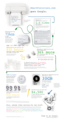
To answer some of these questions, we’ve created the Go Google cloud calculator to let you take a test drive into the cloud. Whether your company is big or small, brand new or been around for a while, this tool will give you a sense of the benefits of going Google in an easy-to-understand way. Here’s a quick demo:


Once you take a spin and learn about the potential cost and time savings, the tool will create a custom URL, presentation PDF, spreadsheet or even a poster that you can share with other decision makers within your business as you discuss going Google.

To show you a real-life example, we asked one our customers, Smart Furniture (you may remember them from their recent guest post), to test-drive the tool for us. And here’s their poster:


So if you’ve been thinking about moving your business to the cloud, take a couple minutes and see what it would be like to go Google. Be sure to tweet and share your results. The Go Google cloud calculator can be found at www.gonegoogle.com.


Read more: http://googleblog.blogspot.com/2010/06/take-test-drive-into-cloud.html

Wednesday, May 19, 2010

MapInfo Stratus OnDemand Offering


MapInfo styrer imod skyerne ...
/Sik


MapInfo making a cloudy move ...
/Sik

Quote

MapInfo Stratus is designed for spatial data owners, web developers and MapInfo Professional users within organizations who need to share corporate data. Whether it’s publishing data internally across the organization or externally to communicate with customers, MapInfo Stratus is a web-based mapping application that provides live information about the location of assets and services.

MapInfo Stratus is delivered as a single mapping portal to display a multitude of data online. It is very quick to set-up and is managed through a web-based administration console. Spatial data is securely uploaded to the cloud where it can immediately be accessed by a range of users through a web-browser. Within a few clicks your data is available to those that need it, when they need it.

MapInfo Stratus with information callout.

MapInfo Stratus with information callout.


Read more: http://www.pbinsight.com/products/ondemand-offerings2/mapinfo-stratus2/

Friday, April 30, 2010

ArcGIS for Amazon Jumpstart Package


Outsource din GIS installation i skyen ...
/Sik


Your future productivity center in the cloud?
/Sik


Quote

ESRI offers a professional services package called ArcGIS for Amazon Jumpstart. The Jumpstart package provides installation, configuration support, and technology transfer on a number of standard topics for setting up ArcGIS Server on Amazon’s cloud platform.

ArcGIS Server is not included with the Jumpstart package. You must acquire or use your existing ArcGIS Server Enterprise Advanced licenses to take advantage of this offer.

What is included in the ArcGIS for Amazon Jumpstart package?

The ArcGIS for Amazon Jumpstart package is a consulting service. It includes one week of up to four (4) days of onsite consulting. During this engagement, the ESRI resource will cover the following standard activities:

  • Amazon Web Services (AWS) orientation
  • ArcGIS Server for Amazon Machine Image (AMI) instance setup and configuration
  • Sample data set loading
  • Create and validate sample ArcGIS Server services
  • Create custom AMI based on supported configurations

Upon completion of the standard activities, any remaining hours may be used to address the following topics:

  • High Availability and Scalability Architecture
  • Data Backup and Snapshot Creation
  • Security Considerations
  • Monitoring Considerations
  • Caching Strategies

What AMIs are available with ArcGIS for Amazon Jumpstart?

The following ArcGIS for Amazon AMIs are available:

ArcGIS Server AMI

  • ArcGIS Server 9.3.1 SP1 .Net on Windows 2008
  • Includes Network, Spatial, 3D and Geostatistical extensions
  • Desktop 9.3.1 SP1 (for administration of ArcGIS Server services only)
  • SQL Server Express v2008 (as a repository of users in case user needs to secure access to services)
  • A 100Gb drive for GIS Data

Enterprise Geodatabase AMI

  • PostgreSQL database v8.3.8 configured for use as an Enterprise Geodatabase on Windows 2008
  • A 100Gb drive for storage of data.

Users will be able to launch any type of 64 bit instance from the AMIs. Instances can be launched as either on demand or reserved. Amazon fees as indicated per each service/ component used will apply, and will be up to users agreement with Amazon based on their account.

For more details about Amazon Elastic Compute Cloud features and functionality, visit Amazon EC2.


Read more: http://www.esri.com/partners/alliances/amazon/arcgis-jumpstart.html

Thursday, April 29, 2010

How Will GIS Companies Weather the Gathering Cloud Computing Storm?


Der er lang vej endnu ...
/Sik


Cloudy, cloudy, foggy ...
/Sik


Quote
The debate about cloud computing and software as a service (SaaS) is well and truly over. SaaS has just too many advantages to offer customers and end-users for anyone to credibly argue against it. The pay-as-you-go service model provides ease-of-use, scalability, reduced maintenance and support effort, and lower total cost of ownership, which means that more and more customers expect SaaS or cloud options when they evaluate new business software. But what does this mean in the world of GIS where change and technical advances have tended to be a bit slower than in many other business software categories? We know the potential that GIS and online mapping and analysis can offer to solve complex business problems, but can GIS software and the use of spatial data evolve to meet the needs of a world that consumes its software as a service in the cloud or do we need to rip it all up and start again?

[...]

So where stands GIS and the mapping software companies as regards the cloud and SaaS? Certainly a lot of organizations are paying lip service to the concept and a few vendors have introduced SaaS offerings of one sort or another. But for existing GIS software vendors to successfully provide GIS as a service they first need to make the obvious significant philosophical leap: They need to stop thinking like software companies and start thinking and acting like service providers. There is little evidence in the announcements so far that the larger GIS software incumbents have made the mind-shift. This mirrors the pattern in other software categories. Just ask Marc Benioff, founder of probably the best-known and most successful cloud computing company, Salesforce.com. He claims his big rivals in the customer relationship management space, Oracle and SAP, don't have what it takes to make a go of it in the new cloudier climate. He could be wrong, but history would support his point of view. Innovation and major paradigm shifts - such as what is required to move from providing traditional on-premise solutions to offering software purely as a service - are not easy for large incumbent technology vendors.