Thursday, June 3, 2010

Claim your business on Google and make the most of soccer fever!


Snart bliver din tv skærm grøn ...
/Sik


Soon your tv screen will turn green ...
/Sik


Quote

People all over the US and Canada already use Google Maps to search for pubs, bars and restaurants in their local area. And with soccer’s biggest event fast approaching, millions of fans will be looking for a great venue to enjoy the tournament. Now is your chance to create your free Google business listing and stand out during the games.

This will only be available for a limited time, so make sure that you sign up before May 31, 2010!

Just follow these 3 easy steps to set up your Google business listing:

  1. Click "Register Now". If you do not already have a free Google account you can create one first.
  2. Enter your personal access code on your ticket and you’ll find your business’s key address information already in place for you. Add to this basic information with details about your business, such as opening times.
  3. Flag yourself as a viewing location to make the most of soccer fever!


Read more: http://www.google.com/landing/showfootball/

Interact With The Dymaxion map


Sjovt, men kun et par gange ...
/Sik


Fun fun fun ...
/Sik

Green River Utah Structural Geology 3D Visualization


Spændende blanding af ny tog gammelt, af analog og digital, af virkeligheder ... En udvidelse af den kendte verden ind i en ny dimmension ...
/Sik


Mixing new and old, mixing analogue and digital, mixing realities ... Extending the known world into a new dimension ...
/Sik


Quote

The geological maps seen in these visualizations are constructed using data from a publication titled "Geologic Map 180" created by the Utah Geological Survey, a division of the Utah Department of Natural Resources (we have obtained permission from the UGS to use this publication as a basis for our visualization). The maps are authored by Hellmut H. Doelling of the Utah Geological Survey in the year 2001. The elevation surface of the region is modeled from the National Elevation Dataset using 10m spaced data points and Landsat natural color mosaics are applied as surface textures in the non-geographic overlay version of the animation.

Our visualization begins with a north-up overhead view of an area of Utah between Green River and Moab. The La Sal mountains are in the lower right portion of the viewpoint. Both Landsat satellite imagery and geological interpretive maps are overlaid onto a flat surface, which will later become three dimensional. As the camera moves into position near the South East corner of the working area, the geologic cross sections will be extruded to true height above sea level, reaching vertically out of the flat terrain surface.

Read more: http://www.youtube.com/watch?v=5CHd6_cIT44

Visualizing the BP Oil Spill Disaster


Hvor mange supertankere skal der til for at rumme den mængde olie?
/Sik


Oh, yes it's big ...
/Sik

Quote
An explosion on the BP operated Deepwater Horizon oil rig killed eleven crew members on April 20, 2010m sparking the greatest environmental disaster in United States history. In combination with the Texas City Refinery Explosion and the Prudohoe Bay Oil Spill, this marks the third serious incident involving BP in the United States in the last five years. Current estimates put the amount of oil being discharged from the broken well at above 1,050,000 US gallons per day! There are over 400 different species of animals living in the area affected by the spill. 253 sea turtles and 29 dolphins have been found dead within the spill area (NOAA).


Read more: http://www.ifitwasmyhome.com/

PAKISTAN: Lake Disaster Triggers New Displacements

Up until Saturday the Attabad Lake in northern Pakistan had been rising one meter every day and was thus on the verge of breaking its banks, observed Lieutenant General Nadeem Ahmed, chairman of the National Disaster Management Authority (NDMA). In the last four months, the water level had been rising in the lake due to glacial melting, swelling it to 18.5 kilometers long and 107 meters deep, he explained.


Then what he had feared all along happened over the weekend when the Attabad Lake in the Hunza Valley in northern Pakistan broke its banks, which were over-topped with water flowing into the spillway.

The water pressure is low but the artificial lake could burst in the next 12 hours, resulting in massive floods in the region, said Ahmed. If that happens, he said, another major disaster could be in the offing.

On Jan. 4, following a snowstorm, a massive landslide hit the village of Attabad, in Pakistan-controlled Gilgit-Baltistan (G-B), an autonomous territory in the northern part of the South Asian country with an estimated population of one million. Initially, it forced some 1,200 people to evacuate their homes. The resulting debris blocked Hunza River, creating a lake now known as Attabad Lake.

As the lake swelled, another village, Sarat, was also submerged while two others were inundated by floodwaters.

"As a result of the formation of the lake, four bridges that linked 16 villages upstream and the 22-kilometer Karakoram Highway linking Pakistan to China have been submerged in water," said Asif Hussain, spokesperson of the Pakistan Red Crescent Society (PRCS) in G-B.

With another disaster looming and to preempt a "worst case scenario" – a lake outburst flooding – the NDMA had as of May 24 evacuated close to 17,000 people from 34 villages downstream, including Attabad and Sarat villages, and along the spillway to safer locations, said Brigadier Sajid Naeem, NDMA's spokesperson, in a phone interview with IPS from Islamabad, the capital of Pakistan.

"This has been done to avert human casualty (and) as a precautionary measure in case breaches are created in the hurriedly dug up 450 meter-long drainage channel and it (the spillway) collapses," said Naeem.

Landslides and flash floods are a seasonal occurrence in the G-B region, which is surrounded by the Himalayas and the Hindu Kush and Karakoram mountain ranges.

Simi Kamal, a geographer and a water expert, said while the direct cause of the lake disaster was a landslide that blocked the water's path, the impact of climate change, which are believed to have triggered extreme weather conditions, could not be ruled out.

"Indirectly, it is linked to climate change, because the whole water balance and ecology of the Himalayan region is changing, causing instability," she pointed out.

A United Nations-backed report released in December 2009 said climate change was posing serious threats – one of which is catastrophic flooding – to the Hindu Kush-Himalayan region. The report was the result of a two-year pilot assessment jointly conducted by the U.N. Environment Program, the Center for International Climate and Environmental Research and the International Center for Integrated Mountain Development.

The PRCS, an affiliate of the International Federation of Red Cross and Red Crescent Societies, is assisting the NDMA in the construction and management of camps for internally displaced persons (IDPs) in schools and health centers around the mountainous Hunza Valley in G-B.

Gulfam Jaffar, 23, and her family of six have been living in a primary school- turned relief camp in Altit village in Hunza Valley since Jan. 6, two days after water flooded their village near Attabad, killing 19 of her kin.

According to Jaffar each classroom has between four to five families. "It's very crowded," she said.

Five months since they lost everything and ran to safety "with nothing but the clothes on our backs," Jaffar, a village schoolteacher, sees little hope of returning to her village soon. "My village is now many feet under water," she said desolately.

Unlike Jaffar, some 800 residents of Rahimabad village near Attabad, who have been displaced by the landslide, have had to move into tents set up by the PRCS because of the limited space in public evacuation centers.

"Arrangements have also been made to ensure provision of relief goods to the 16 villages with a population of about 25,000 that have been cut off from the rest of Gilgit-Baltistan due to the lake," said Naeem.

With all roads closed, bridges submerged, the only way to extend assistance to the IDPs is through helicopters, he said. The NDMA has deployed seven helicopters in Gilgit to transport people and goods.

The United Nations Children Fund said it had already sent 750 sanitation facilities to the IDP camps and pledged a continuous supply of potable water supply for up to 30,000 persons.

In anticipation of catastrophic flooding and widespread displacement of the affected villages in the event of a lake burst, the NDMA has set up at least 31 more IPD camps in two of the seven districts of the Gilgit-Baltistan region.

Source:
Reuters AlertNet, "PAKISTAN: Lake Disaster Triggers New Displacements", accessed June 1, 2010

Wednesday, June 2, 2010

Metaio presents: next generation augmented reality browsing


Karlsons klister ... Lim rumlig information fast til den virkelige verden ...
/Sik


Augmented Reality is (also) the process of gluing spatial information til real live objects ...
/Sik

Quote
Metaio`s exciting new "augmented reality" browser junaio® has extended its capabilities beyond the usual location based internet services. Not only may the user obtain information on nearby POIs such as shops, restaurants or train stations, but the camera`s eye is now able to identify objects and "glue" object specific real-time, dynamic, social and 3D information onto the object itself. This unique feature is now being extended through collaboration with kooaba and its visual object search capability, providing access to kooaba`s extensive object databases. Initially available on Android, an iPhone release will follow soon.


Read more: http://www.youtube.com/watch?v=Tz-lYtzKpTo

Take a test drive into the cloud


Skyhøje priser eller tågedis over landet ... ?
/Sik


Buy a small piece of the Internet ... Go Google ...
/Sik

Quote
We’ve talked about the power of cloud computing and how millions of businesses have alreadygone Google by switching to Apps. But sometimes it’s hard to imagine what working in the cloud would really mean, and frequently, people ask us how they can better understand the benefits of Google Apps specifically for their business. How would online collaboration really affect your workplace? And how could increased email storage or integrated IM and video chat actually impact your company’s productivity?

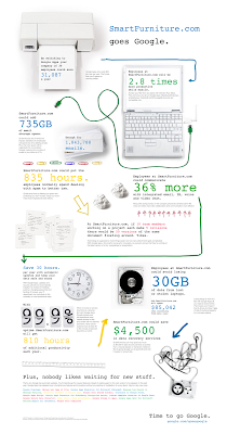
To answer some of these questions, we’ve created the Go Google cloud calculator to let you take a test drive into the cloud. Whether your company is big or small, brand new or been around for a while, this tool will give you a sense of the benefits of going Google in an easy-to-understand way. Here’s a quick demo:


Once you take a spin and learn about the potential cost and time savings, the tool will create a custom URL, presentation PDF, spreadsheet or even a poster that you can share with other decision makers within your business as you discuss going Google.

To show you a real-life example, we asked one our customers, Smart Furniture (you may remember them from their recent guest post), to test-drive the tool for us. And here’s their poster:


So if you’ve been thinking about moving your business to the cloud, take a couple minutes and see what it would be like to go Google. Be sure to tweet and share your results. The Go Google cloud calculator can be found at www.gonegoogle.com.


Read more: http://googleblog.blogspot.com/2010/06/take-test-drive-into-cloud.html